The “All-Star Soundings”

One of the highlights of my undergraduate synoptic meteorology course at Oklahoma was the first three weeks — the “all-star soundings,” our individual presentations of notable weather events which had classic signatures on the Skew-T diagram.  Dr. Kenneth Crawford was one of the best teachers I ever had, and I loved this part of his course so much that I’ve kept the name and tried to carry on the tradition.

This post is simply a way for me to keep track of all the events I’ve collected on my “all-star” list.  I’ll come back and add more as I find them, as people suggest them, etc.  Don’t hesitate to submit your own: by sharing this list publicly I want to make it more of a community effort.  Ideally, while the events from pre-2005-ish are good, there is much more data available online for those that are more recent; I’m most interested in those.

As of right now, the entries don’t have a common format–I’ll change that later.  I might even add links.  They are sorted only by date and season, the way it was when I was a student.  Old habits die hard.

Cool Season Soundings

  • IAD 12 UTC 03/13/1993 – “Storm of the Century”
  • HAT 12 UTC 03/13/1993 – “Storm of the Century”
  • BNA 12 UTC 03/13/1993 – “Storm of the Century”
  • INL 12 UTC 02/02/1996 – Arctic Air Outbreak
  • LCH 00Z 01/13/1997 – Ice Storm
  • WMW 00 UTC 01/06/1998 – Ice Storm
  • Buffalo – Lake Effect Snow Christmas 2001
  • CRP 12 UTC 12/25/2004 White Christmas in South Texas
  • JAN 15 UTC 12/11/2008 – Deep South Snow/Heavy Rain
  • OKX 00 UTC 12/27/2010 – NY Blizzard with Thundersnow
  • DNR 12 UTC 12/22/2011 – Upslope Snow
  • January 2014 – the “Polar Vortex” Cold Air Outbreak
  • February 2014 Southeast Ice Storm
  • Buffalo Record Lake Effect Snow – November 2014

Warm Season Soundings

  • CKL 12 UTC 03/27/1994 – Palm Sunday Tornado Outbreak
  • TOP 00 UTC 04/11/2001 – Hailstorm
  • LIX 06 UTC 08/29/2005 – Hurricane Katrina
  • JAX 00 UTC 08/22/2008 – Tropical Storm Fay
  • LCH 12 UTC 09/13/2008 – Hurricane Ike
  • JAN 18 UTC 04/24/2010 – Yazoo City, MS Tornado
  • BMX 18 UTC 04/27/2011 – April Tornado Outbreak
  • SGF 00 UTC 05/23/2011 – Joplin Tornado
  • ILN 00 UTC 05/26/2011 – Indiana Tornadoes
  • ILX 00 UTC 07/12/2011 – Derecho
  • Hurricane Irene – August 2011
  • High Risk / Ohio Valley Tornado Outbreak – March 2012
  • OUN 00 UTC 08/04/12 – Plains Heat Wave
  • Wildfire in Arizona – June 2013
  • Colorado Record Flooding – September 2013
  • Detroit Flooding August 2014
  • Calbuco Eruption, Chile – April 2015
  • CRP 12 UTC 10/30/2015 – Record TX Rainfall

I’m overwhelmed.

I just can’t figure out how to keep up with all the “social media” accounts I have. At least not all of them at the same time. Maybe this think-out-loud post, or some of your comments, will help.

As with most people, I’ve used Facebook to stay connected with family and friends, but I haven’t posted there much lately at all. I’m not losing touch with anyone (any more than I already have!) — instead I’ve been sharing more of my quick thoughts, ramblings, and science link finds on Twitter. That’s where most of my science- and teaching friends and colleagues are, where our dialogue is, where the community is. It means that my own  feed is a mosh of weather, education, political ramblings and sports quips, but it works. I could separate those into multiple accounts like some of my friends do, but so far I have refused because I am one person. A very complicated person, but one with lots of interests, from Alabama to Z-R relationships.

This summer I joined Instagram for its intended purpose, photo sharing. That site has become my happy place — a no-spin, no-bad-news zone. Come over and sit a spell.

When I don’t want to be bothered by anyone I know, there’s Tumblr, which for me is more for kitten animations and funny pictures and such. That leaves us with this blog, which in my mind has an identity crisis. I don’t know what I want to put here. And more so a time crisis, which is the essence of this rambling — I just simply don’t know how to juggle all of these. I already have way too many emails to answer and text messages to read and write. And course materials and websites (with blogs, ugh!) to maintain. And a couple personal websites I run. It always seems, however, that when I focus on one or two, the others take a hit in activity. How do you all do it?? How do you keep up track of all your platforms and media at the same time without becoming paralyzed by it all??

My favorite media from April 9

In addition to just serving as a “blog,” I want to use this space to curate some of the images, videos, and links used in class for specific weather events.

The tornadoes of April 9 in Illinois (and elsewhere) are a good starting point.  Don’t hesitate to offer additions or corrections.  Each list like this will probably be updated at random times in the future.  Almost all these will be linked from source–I’ll provide acknowledgments for any that aren’t.

Videos

Photos

Data, other items, etc.


I love cumulative exams.

In a recent Faculty Focus post, Maryellen Weimer argues in favor of cumulative or comprehensive exams, which most of my students aren’t particularly fond of.  [grin]  Put very simply, she says “Students don’t like cumulative exams for the very reason we should be using them: they force regular, repeated encounters with the content.

This post is a reminder to me to include more of my old test questions.  They are ideal for in-class discussion, formative and summative assessment of student understanding for a course unit, and even to help me identify vague or confusing questions.  (There have been a couple of those lately–so I’ve resolved to punt them off the exam and use them in class next semester so I can figure out how to fix them.)

I also love the ideas to bring up older course material as a way to instill better cumulative/comprehensive study habits.  Almost all the courses I teach have at least some long-term scaffolding to them (shouldn’t we be designing our courses that way???), and I need to do a better job of cultivating these skills in my students.  This was spring break week on my campus, and Monday I think I’ll open with a pop quiz based on her last item:  “Your friend Leo wasn’t in class last week.  He texts, asking what happened in class.  Text Leo a short answer and don’t tell him ‘nothing’.”

On scaffolding and learning outcomes

About 10 minutes into the first class meeting…..”I expect all of you to come to class prepared…”

Yawn.  *clicks back to Facebook tab*

Prepared to do what?  Listen to a lecture for an hour every day?  How do I need to prepare for that beyond making sure my laptop battery is fully charged?

Or perhaps, we should ask (and expect) our students to show up prepared for an active class period full of questions, problems, what-ifs, discussions, and ultimately some answers.  So how do we do that?  I try my best to follow Robert Talbert’s guide to creating learning objectives.  Seriously, that little blog post may be one of the best explications of how to design effective, active classrooms that’s ever been produced

To provide an example, I’ll return to the “difference between HP and LP supercells” outcomes I wrote about last fall.  In a course unit on supercell archetypes where we want students to “know the difference between LP and HP supercells,” we might come up with these:

“At the end of this section, students will be able to:

– state the physical differences between LP, classic, and HP supercells;

– recognize the different overall structure between the conceptual models of the three types;

– identify which types are more/less likely to produce tornadoes, strong “straight-line” winds, and large hail;

– describe how environmental wind shear plays a role in modulating supercell type;

– describe how atmospheric water vapor and/or cloud base height play a role in modulating supercell type;

– sketch and label archetypal models of LP, classic, and HP supercells, including cloud and precipitation extent, updraft location relative to precipitation, surface outflows, and the most likely location of a tornado;

– differentiate between supercell modes using radar data; and

– differentiate between supercell modes in photographs and/or videos.”

Wow.  That’s a lot to accomplish…probably multiple classes!  I think these are listed roughly in order of increasing difficulty–which is the point–and it would be very easy for me to just sit back and put together 80 or 90 slides that cover everything, and then test students on what I think is important.  But I’d rather have them do some Preparation H (homework!) and come to class armed with some basic vocabulary and knowledge.  That way, we can get further down the list and spend our class time really diving into and interpreting the radar data, pretty pictures, and complex videos.

So here’s my approach.  Before the class period(s) on supercell types, students are expected to be able to perform the first three, maybe four, tasks on that list.  Yes, I expect them do be able to do these things before coming to class.  The activities for this unit would probably involve reading (Ahrens Extreme Weather and Climate pp. 311-5), looking at additional material (this nice and quick summary by Zach Roberts), and answering short questions online before class (the Just-in-Time method; my example questions for both days of this unit are at the bottom of the post).  If students have done the requested assignment, and spent time digesting it and trying to understand it, they should be able to answer these questions easily and will be well prepared for two productive and fun class periods.

Class time would begin with a follow-up on anything that students identify as still unclear, and a review of their answers to the pre-class questions.  This typically only requires 10-15 minutes; after that, we move on.  For the students who didn’t answer the questions, and didn’t show up prepared, they are going to be seriously lost for the rest of class.  It is imperative that students realize their success in class depends on coming to class prepared.

It’s then on me to select the right kind of in-class activities to achieve the last 4-5 objectives in the list.  Just a few ideas:

  • I might draw three different vertical shear profiles on the board, and ask students to discuss and then draw in what the Cb would look like — barely tilted in weak shear, somewhat tilted in moderate shear, and very tilted in strong shear.
  • Provide a printed color copy of reflectivity and velocity data for a classic supercell, to let students draw on and place the mesocyclone relative to the precipitation.  (And then identify and label the “hook echo.”)
  • Giving the customary supecell schematic with most (or all) of the labels missing, and ask students to label pertinent features.
  • Display Figure 7 from Rasmussen and Straka 1998, and ask students to identify which bar graphs correspond to LP, CL, or HP storms.
  • Or others, depending on how students respond to the pre-class questions.

This set of learning outcomes, arranged in approximate order of difficulty, is precisely what I would give students as a “study guide” for these class meetings.  Exams would include questions that test a range of these outcomes.  The ‘A’ students will successfully use photos and videos and radar, the most complex tasks we do; the ‘B’ students will be able to relate supercell types to environment and to label their models; the ‘C’ students may only know the LP/CL/HP differences and the tornado risk from each.

I’ll close with Talbert’s last sentence, which is a superb summary of this process:  “This is far from a perfect system, but it’s a reliable way to align learning objectives with the actions you want students to perform and the means you want to use to assess them, and it gives students a key ingredient for self-regulated learning: A clear set of criteria that will tell them what they need to know and how to measure whether or not they know it.”

– – – – –

Students submit answers to these questions online before the first day:

1. The textbook omits large hail from the list of hazards for one of the three supercell types.  Which type is less likely to produce large hail?

2. Name two differences you see between the HP and LP photographs in the online reading.

3. Radars can be helpful in determining supercell type (LP/classic/HP).  Why do you think that’s the case?

4. Name one thing about either reading that was unclear, confusing, or that you would like clarification on.

Before the second day:

1. The author of this video has declared this storm to be an LP supercell.  Do you agree?  Why?  How would you compare it to the photo and schematic you’ve already seen?

https://www.youtube.com/watch?v=BF8XManeSn0

2. Name one thing that was unclear about yesterday’s discussion that is still unclear, confusing, or that you would like more clarification on.

Turbulence and mixing at the power plant

Hot, moist exhaust from the campus power plant stacks mixed with frigid air this morning to produce some great turbulent flow and even some “mixing clouds.”  (Video is 90 seconds; I zoom in a bit at 60.)  My favorite part: notice that the interior of each plume remains somewhat clear–that’s the part of the “updraft” that entrains ambient air last, so in this case, it stays clear the longest.  Neat!

As for the clouds, this is the same process that causes airplane contrails, and your breath to appear in winter.  For more information, here’s the AMS Glossary definition of mixing clouds and here’s a quick explanation using temperature and vapor pressure from the Hong Kong Observatory.

I’ll look for a couple of good explanations & links related to entrainment and update this when I have the chance.

Why I don’t give extra credit

Since the title explains itself, I can dive right into the reasons.  There’s not always a need for a long, drawn-out introduction!

1. I’m a meteorologist, and we don’t do that.

Put very simply, we don’t get a chance to “make up” for a bad forecast.  We can only learn from our mistakes, move on, and do better the next time.  It’s illogical to think that a forecaster’s mistakes — no matter if they are major or minor — can somehow be washed off his record by doing bonus work.

An example of minor mistakes: the forecaster who continually has a warm bias to his temperatures.  Once you realize what you’ve done wrong, fix it!  Explaining to people why you made the mistake is important, yes — but does not absolve the mistake.  (See #2 below for more on this.)

A major mistake: missed forecasts can have fatal results.  In a recent 5-year period, 17 tornado fatalities occurred without a tornado warning being issued (Brotzge and Erickson 2009).  There is no apology great enough to overcome this one.  I know this all sounds painfully harsh and trite to those who aren’t as familiar with the forecast process.  But put simply, in our field these are the lessons we face every day.  I’m a firm believer that students should experience science as science is practiced, and a no-extra-credit policy is a clear application of that principle.

2. My ideas of sound pedagogy don’t support that model.

Four reasons instructors may offer extra credit are given in this Faculty Focus blog post from 2011.  None of them convince me.

  • “It reduces student anxiety and builds confidence.”

This is the only one that holds some water to me.  But this is exactly what practice assignments and homeworks should be designed to do, right?  Build confidence so that students can perform well on major assessments?  Aren’t we already supposed to be designing our courses to that students are well-prepared for exams?  I don’t understand how something like attending an evening seminar about a peripheral topic (a classic extra credit idea) builds confidence.

  • “If learning is the goal and students haven’t learned important content, extra credit offers a second chance to master the material.”
  • “Not all students ‘get it’ the first time.”

Teachers of college writing know that revision is a key to students improving their writing skills.  In the hard sciences we might use the word practice, especially in meteorology where forecast opportunities are fleeting and revisions to previous work aren’t possible.  I don’t remember but I’m pretty sure my first few forecasts as an undergraduate were awful, and that they improved with repeated practice (to the somewhat less-awful state they’re in now!).  Our assignments and courses should be arranged to give students multiple opportunities to master difficult content before a major assessment takes place.  When we don’t provide this structure, we are less effective teachers.

  • “Students are motivated to do it, so why not capitalize on this motivation by creating a robust learning opportunity.”

It’s a bit cynical but to me the implication here is that students aren’t motivated for ordinary classwork.  I certainly hope that’s not the case!  Every learning opportunity should be robust and motivational.  If it’s not, it doesn’t belong in our classroom.  Why should we relegate our most creative assignments for extra credit opportunities that may get done by only a handful of students?

One thing to point out is that I differentiate between large, formal “extra credit” assignments and the rare “bonus” questions that occur on a quiz or an exam: Michael Leddy offers a nice example and his take here.  Most often, I use those to help me scale exam or course grades to better align with student expectations (I’ll rant about the insistence of a 90-80-70 letter-grade cutoff some other time).  But my students can attest that I do this about once per course and is part of an assessment that already exists.  My bonus questions are always opt-out (right there on the page for you to try), not opt-in (available only if you ask or by doing something else external to class).  I’ll avoid saying much about the ethical issues of opt-in extra credit, too, beyond saying that they terrify me.  Is the extra work only available to students who ask?  Are they allowed to tell their peers?  What if someone can’t attend that special guest speaker’s talk because of their job or family?

So there you have it.  Let’s make our coursework compelling the first time ’round, and let’s create assignments that are not busy work but help students learn what we truly want them to do.  That way, they get it right when the grades are on the line.

Sirens, Tornado Warnings, and Messaging

TL;DR version: Sirens go off if any part of the county is put under a warning, even if the risk is nowhere near your part of the county. YOU may not even be at risk. 

Last night in Bloomington was a textbook case of how complicated the “weather warning business” really is. Here’s a rundown of the most important issues.

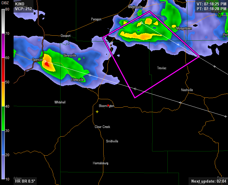
Warnings. Since 2007, the National Weather Service has issued tornado warnings not by county but by risk area–it’s called a “polygon” because, well, it looks like one:

The area in that pink box is the area the experts at NWS in Indianapolis placed under a tornado warning, for the storm that’s also in the box (this is a pretty standard weather radar image that you’d see on tv, with red indicating heavy rain and hail and the small green triangle also an indicator of hail). This image is of the first tornado warning from last night. Notice how this box does not include any part of downtown Bloomington, or the heart of the IU campus (red dot), or even my house (yellow plus).  This polygon is the box I use to make my own safety decisions.  Any weather app that’s worth its salt will plot these polygons. Look at that image again. For the entire time the warning was in effect, NWS predicted that the storm would remain in that box (and it did). There is no reason to panic or to take shelter if you’re not in the path of the storm–which is what the box shows for this warning.

As the NWS office in Birmingham, Alabama says“It is our goal that only those inside the polygon should take action.”

Sirens.  Many siren systems in the US are still sounded by county. That means that no matter how small the sliver of your county, if any part of the county is placed under a tornado warning, the sirens will go off everywhere. This is true in Monroe County–it happened twice last night. So the takeaway messages are:

  1. Sirens do NOT always imply that your location is in danger. They imply that some PART of your county is in danger. The storm may stay 10, 20, or even 30 miles away from you.
  2. Sirens are sounded by a county employee (at least here). No one on the IU campus, to my knowledge, has any control over the sirens. None.

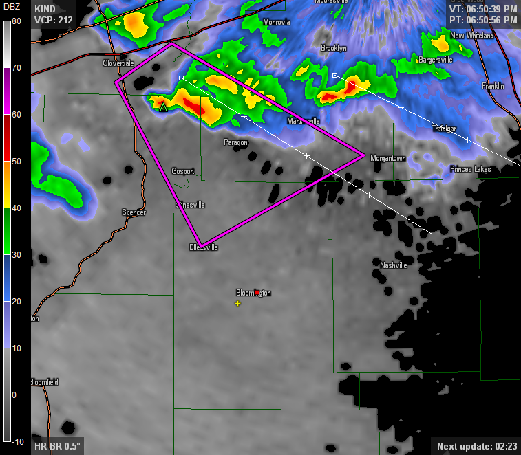
By the way, the sirens went off twice in Bloomington last night. The second time was for a storm that was forecast to clip the northeastern part of Monroe County.  Here’s the radar and tornado warning polygon for the second one:

Again, no risk for Bloomington.  Zero, zilch, nada.

Confusion. Last night got a little squirrely because IU sent messages telling everyone to seek shelter for the first warning, but for the second warning, some messages told people that campus was not being impacted. For once, the polygon seemed to matter! This should happen in every event. This should become the standard and not the exception. (For the record, it’s the first time in my 3 years of living here that I’ve seen this happen.)

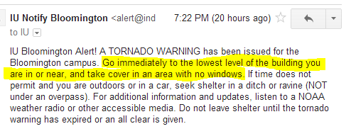
Here’s what we absolutely cannot do. Send this email:

And then send this tweet:


This is a messaging and safety nightmare.
Why would I “take cover” for something that “does not impact” me? Which one of these messages should people listen to, if either one? Just as mixed messages from faculty to students lead to protests and grade changes, mixed weather information leads to fatalities. This storm was of absolutely no risk to Bloomington, but the message implied it was. Until it wasn’t.

My personal view is that we all have to make our own safety decisions. I realize that if you live in a residence hall, or work at a big-box store, you may be required to follow someone else’s instructions. Based on the above, I’m honestly not sure what those instructions would have been. With that in mind, I’ve always believed and said that you and you alone are responsible for your safety. Make the decisions you need to make and do what you have to do, whatever that may be. That goes both for both seeking shelter and coming out from shelter so you can get on with your life.